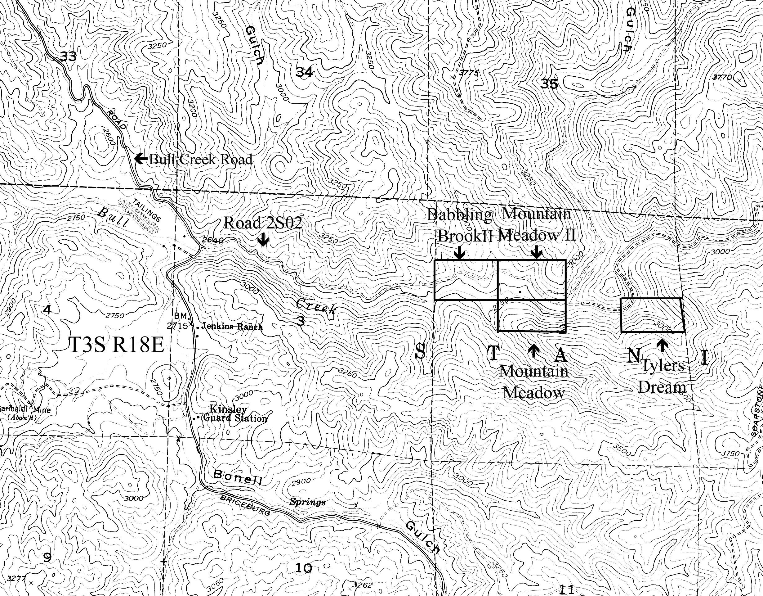
| Claim name | Babblin Brook, Mountain Meadow 1 and Mountain Meadow 2 |
| Location | 15 miles south of Groveland CA |
| GPS Coordinates (Babbling Brook) | 37.704273,-119.959723 37.706655,-119.959723 37.706655,-119.954597 37.704338,-119.954474 37.704273,-119.959723 |
| GPS Coordinates (Mountain Meadow) | 37.704273,-119.959723 37.702407,-119.959723 37.702407,-119.954474 37.704338,-119.954474 37.704273,-119.959723 |
| GPS Coordinates (Mountain Meadow II) | 37.706655,-119.964564 37.706655,-119.959723 37.704273,-119.959723 37.704273,-119.964483 37.706655,-119.964564 |
| Size | 60 acres |
| Dangers | Bear, rattlesnakes, cougars and abundant poison oak. |
| Access | Very good. Gravel road. |
| Gold | Good fine gold, pickers are common. |
| Methods of mining | Year round water in Bull Creek (all but one year to our knowledge). Panning, sluicing, high banking, metal detecting, crevicing, hole punching and bedrock busting. |
| History | Little is known about the history of this portion of Bull Creek as we have been unable to find anything written on this particular portion of the creek. We have found some very old artifacts dating back to the 1850’s miners with metal detectors (shovels, hand drills and wedges). This claim runs along and up to Soapstone ridge, a ridge where we know a man lived in the 80’s and found over 1 million dollars of gold “somewhere” up on Soapstone ridge. The man has since died, but did tell one of our close friends to “remember Soapstone” just before his passing. These are three basically contiguous claims, has an excellent campground, with a bathroom and normally has year round water except for 2013 and 2014. There are benches on these claims which should be focused on. |
| Video | For a panoramic video of the claim, click here (coming soon) |
Please remember to leave the claim cleaner than when you arrived.
Babblin Brook, Mountain Meadows 1, Mountain Meadow 2
From Coulterville, CA, take J132 through Greeley Hill to Greeley Hill Road. Turn right on Greeley Hill Road. Go straight to one-lane bridge. Turn right onto the dirt road marked Bull Creek Road or Road 20. Follow the road until you cross a small one-lane bridge. Turn left onto road 2S02. Drive about 1½ miles and the campground will be on the right. Turn right into the campground. This is Mountain Meadows 1 and Mountain Meadow 2. The markers are next to the stream in the middle of the claim. Babblin Brook’s marker is at the west end of the campground, just past the dirt mound. The USFS has a pit toilet in the campground. Tyler’s Dream is no longer a SPA claim.
Babblin Brook 20 acres N ½ SW ¼ NW ¼, Sec 2, T 3S, R 18E, MDM
CAMC285816
GPS Location of monument 37° 42.20′ N, 119° 57.30′ W, Elevation 2711ft
Mountain Meadows 1 20 acres S ½ SE ¼ NW ¼, Sec 2, T 3S, R 18E, MDM
CAMC285819
GPS Location of monument 37° 42.17′ N, 119° 57.23′ W, Elevation 2829ft
Mountain Meadow 2 20 acres N ½ SE ¼ NW ¼, Sec 2, T 3S, R 18E, MDM
CAMC285820
GPS Location of monument 37° 42.17′ N, 119° 57.23′ W, Elevation 2829ft